What is a Geospatial Ontology? (2JO4)
The following summary is a non-technical start on this topic by Dr. Gary Berg-Cross. This discussion reflects some early work by SOCoP members and their demonstrations. It is intended to be a starting point for further input from the SOCoP and broader ontology community on this topic as an aid to the SOCoP INTEROP effort. This is a conceptual level discussion aimed to be understood by domain specialists. It does not try to discuss technical issues such as the use of ontology languages for representing ontological models. Within the INTEROP effort domain experts are not expected to have to deal with this issue. Various OntologyDevelopment_and_maintenance_roles are expected to be used to apportion work. (2QYD)
Ontologies in General (2K0I)
In general an ontology specifies a vocabulary of concepts together with some indication of their meanings. As discussed in Smith and Mark (Do Mountains Exist? Towards an Ontology of Landforms. Environment and Planning B,2003, 30(3), 411-427.) the term ontology is used nowadays by information scientists, in a non-philosophical sense to: (2RZ7)
- "designate the regimentation of such conceptualizations through the development of tools designed to render them explicit." (2RZA)
Ontology in this sense is designed to: (2RZ8)
- "assist in the task of specifying and clarifying the concepts employed in given domains, above all by formalizing them within the framework of some formal theory with a well-understood logical (syntactic and semantic) structure." (2RZ9)
There is a range of levels of precision with which meaning is specified, but an overall goal is for the ontology to be in form (hence it is called a formal ontology) that express a common understanding of the structure of information suitable among people and-or software agents. Often there are twin targets to make the meaning clear to people while allowing a degree of "automated" processing. In this case a formal ontology can be used to make explicit the semantics, spatial cognition and knowledge contained within efforts such as software applications. (2JOA)
Because agreeing on conceptual vocabularies is so important up front on any ontology development INTEROP may run vocabulary development workshops as a first step. See VoCamp for more information on one approach to vocabulary development. (2QYE)
An ontological model is made up of: (2JOU)
- classes/concepts (at least partial hierarchical) along with (2JOV)
- properties & attributes for these concepts (usually with descriptions to help humans) plus (2JOW)
- constraints on properties and attributes (2JOX)
- relationships between and among class concepts as well as between and among class instances (2QYF)
- instances of concepts. (2JOY)
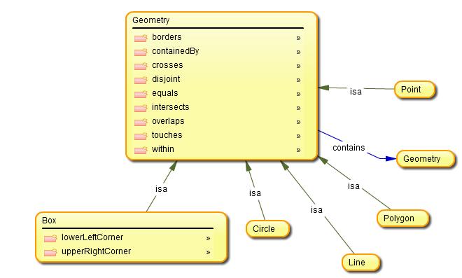
A very simple example is the Geometry ontology which was built using the Knoodl tool. (2T89)
In this diagram Geometry is a Class with several properties (i.e. boundary) some sub-classes (circle is a geometry) and a relations called "contains" which allows one Geometry such as a circle to contain other Geometries such as a point. (2T8B)
The backbone on an Ontology is made up of Classes in a formal Hierarchy. Certain parts of an ontology are the primitives, foundational concepts from which other concepts are constructed. The concept of PART and BOUNDARY are examples of primitives in some ontologlies. (2JOB)
A class is a concept in the domain so we may have a class of organizations (e.g. USGS) or a class of regions (e.g. Mid-Atlantic States). A class also has a population called instances which is the collection of the elements with similar properties defined by the class concept. Thus there are instances of states such as Maryland in the Mid-Atlantic class. (2JOC)
We can illustrate these general ideas using a very small, informal ontology made up of a few geospatial objects and some general relations. The Figure below illustrates an ontology using 3 general relations - part, sub-type and instance describing that portion of the USGS hydrology model for "hydrologic units". The ontological model has 4 sub-types showing a range of aggregation. Thus regions or sub-regions are a type of hydrologic unit and a specific instance of a region is the Mid-Atlantic, which includes as part of it Delaware. For accounting purposes Delaware may be dividing into parts by fiat - in this case and upper and lower part. These are asserted as both part of Delaware and as an instance of an "accounting Unit" defined some time ago by USGS as part of a 5 level hierarchy.
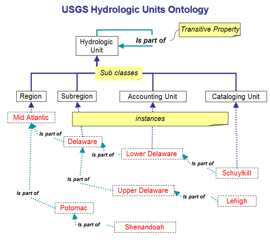 Ontology from Hydrologic Ontologies Framework (HOW) by Michael Piasecki, Bora Beran & Luis Bermudez (2JOD)
A final sub-type of hydrologic unit is a "cataloging unit" which has even finer part of accounting units and in this case the Schuylkill is an instance of this and part of the Lower Delaware accounting unit. A more complete ontology might include features of regions and units such as its size, borders etc. Other ontological models may use different terms for the old USGS concept of "cataloging unit". This 3rd level of the older USGS hierarchy is now officially called "basin" and the 4th level is called "sub-basin" (formerly "accounting unit". Clearly such evolution or vocabularies will happen and mappings need to be maintained from past to current uses as well with vocabularies that were independently developed. It is worth noting in passing that the previously shown Geometry ontology and the Hydrology ontology are orthogonal as presented in these examples. Clearly we could express a relation, but the ontologies themselves don't make the relationship explicit. We might bridge between the 2 by trying to employ the geometry concept of boundary to a hydrologic unit. However, this must be done with care since a hydrologic unit's actual geometry may be complex. Some simple ideas relating the 2 are shown further down on this page as an illustration of Geospatial Ontologies. (2T8C)
Automated tools such as the OOR allow some aligning mapping and matching to be done efficiently. Logical relationships between ontologies and their vocabularies can be supported within the repository, including such things as mutual consistency, extension, entailment, semantic mappings, intelligent search, and decision support. See http://ontolog.cim3.net/file/work/OOR/OOR-Requirements-Research/Requirements-and-Challenges--KenBaclawski_20090814.pdf for a discussion. (2JOE)
Ontologies can be deployed to enable reuse of domain knowledge and to make domain assumptions explicit. It can also be used to separate domain knowledge in a declarative form from operational or procedural knowledge which can be implemented in software. (2JO9)
The broarder ontology community has contributed introductory material on ontology and semantics for the SOCoP community. This includes John Sowa's Integrating Semantic Systems (see http://ontolog.cim3.net/file/work/SOCoP/INTEROP/Integrating%20Semantic%20Systems-Sowa.pdf) and (2QWM)
"Getting Started with Semantics in the Enterprise" by Bradley Shoebottom viewable at http://rmc-ca.academia.edu/BradleyShoebottom/Papers/358330/Getting_Started_with_Semantics_in_the_Enterprise (2QWN)
Geospatial Ontologies (2JOR)
Geospatial ontologies take as their domain a range of geospatial concepts such as geospatial objects (such as in the previous Geometry and hydrologic example), relations (including special ones for spatial concepts) and features. Domain ideas about such concepts can be seen in previous standards efforts such as by the OGC and ISO/TC 211 General Feature Model, but traditional information models often restricted the semantics that could be expressed in such models. More recently efforts such as the W3C Incubator Group on Geospatial Ontologies has looked at "geospatial foundation ontologies to represent geospatial concepts and properties for use on the Worldwide Web" (see http://www.w3.org/2005/Incubator/geo/XGR-geo-ont-20071023/) (2JOG)
Relations (aka predicates as in the proposition "the door is in front of me) start with seemingly basic things such as topological and qualitative ideas of "near", "connected", "in front of" and "around" as well as other common spatial relationships in use, equals, disjoint, intersects, touches, crosses, within, contains, and overlaps. Spatial objects include abstract spatial notions such as "place" or "locations". Geospatial objects, such as a city or lake may be abstracted to geometrical concepts like a point or polygon area concepts in order to be understood at different levels of granularity. Thus an area like DC can be presented as a small oval on a national map or a complex area when zoomed up close. (2JP6)
Features include geometrical ideas such as "size" and "volume" shown in the Figure below. These provide summative information about spatial things.
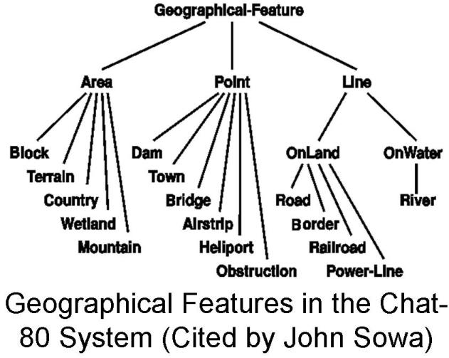 (see http://www.jfsowa.com/ontology/ontoshar.htm#s6) (2JP7)
In this particular application (Chat-80) certain macro concepts like rivers and roads are considered subtypes of lines; while bridges, towns, and airstrips are treated as a simple point feature. This may be adequate for a particular application, but is not a general treatment of geospatial feature and does not make a clean connection to the Geometry ontology previously presented. It does use similar geometrical terms like "point" and "line", but these are types of features and not geometries. (2T8D)
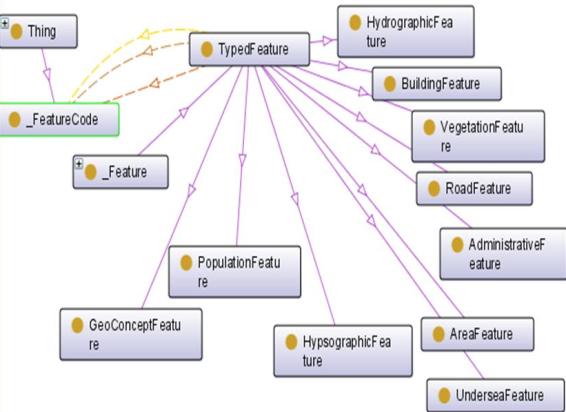
A more general model for geo-features is shown in the GeoConcepts ontology
OWL ontology (see http://www.geospatialmeaning.eu/geo-ontologies-survey/GeoConcepts/GeoConcepts_v1.1_20080301Lite.owl) below
 (2JQY)
This is an improvement in that there are a wider range of feature types from vegetation to hydrologic which are both related to a higher order concept (thing) and the fact that features are associated with feature codes. This reflects the concept that besides simple geometrical ideas geo features need to also include adequate semantics for more macro, aggregated and complex concepts like "bridge", "river", "estuary", "pond" and "lake". Knowledge about each of these would include relations to other things (e.g. each has boundaries with non-water objects, a river may connect to a lake etc.). This is a better ontology since it attempt to define and distinguish all of these concepts in explicit and precise ways to avoid confusions. However, a clean connection to Geometry is not attempted here either. We need further ontologies to provide semantic glue by which diverse sources of information are brought together. At the 2009 SOCoP workshop John Bateman (University of Bremen) discussed ontolgoical issues in bringing together sources as diverse as: (2JP8)
- Location-based services (2JOI)
- Geographic Information Systems (2JOJ)
- Commonsense objects and activities (2JOK)
- Spatial awareness and understanding (2JOL)
- Natural language capabilities (2JOM)
- Robot perception (2JO7)
See John Bateman [slides ] (2JOO)
Getting such diverse areas of expertise to talk to each other is a challenge because the knowledge comes from different communities with different interests and it is often formalized using different (data) representations. For all of these reasons communities, including geo-science communities, wind up with divers pools of knowledge maintained in very different systems unable to share information. (2JOT)
An ontology helps by standardizing concepts expressed by a vocabulary. An example is the term and concept "near". One might want to distinguish something called DC that is near Baltimore and say: If DC is near Baltimore then Baltimore and DC are not connected, and also that if Baltimore is near DC then DC is also near Baltimore. (2JOP)
These can be stated in an ontology as axioms to rule out the possibility of interpreting near as connected (but a connected path with certain attributes such as above flood level between objects may be of interest). One would also need to distinguish "near" from "far" (as part of a scale idea) since neither is connected. (2JO6)
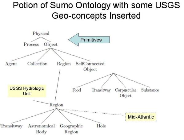
Even ontologies differ starting with different primitives and making different distinctions. Because of this people have developed ontology harmonization and translation mechanisms, a technical topic discussed more at GeospatialOntologies/Ontology_harmonization. But often simple alignments can be made to bring general and domain ontologies, such as geospatial ones together. An example of inserting some of the previous USGS region ontology into another ontology called SUMO (Suggested Upper Merged Ontology see http://www.ontologyportal.org/) is shown below.
 (2JOS)
