One goal of the CyberInfrastructure work of the SOCoP-INTEROP project is to help geoscientists and geographers effectively respond to the increased demand for shared data across multiple distributed groups and professional contexts. As expressed by the US National Research Council help is need to : (2R0H)
assemble geographic information that describes the arrangement and attributes of features and phenomena on the Earth (2R06)
We have targeted three related strands that conceptually make up a global infrastructure. These will help share assembled data and support interoperable use: (2R02)
- Cyber-environments, which enable researchers to access, integrate, automate, and manage complex, collaborative projects across disciplinary as well as geographical boundaries, (2R03)
- Cyber-resources, which ensure that difficult problems can be solved in a timely manner, (2R04)
- Cyber-education to ensure that the benefits of cyberinfrastructure are understood and made available to practitioners no matter where they may be. (2R05)
Responses include both largely technical approaches, addressing 1 and 2 above that builds on how the technical architecture of a geo-spatial cyberinfrastructure fits within the idea of a Spatial Data Infrastructure (a notional version from OGC is shown below) as an enabler of the geospatial web. (2R0I)
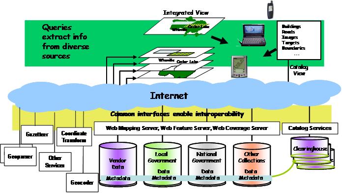
The SDI architecture shows a technical approaches typically combine high-performance computing systems networked across scientific communities supported by massive data storage, visualization systems, and advanced tools. An example of such cyberinfrastructure was the collaborative Geosciences Network (GEON) project which provided support for the Earth Sciences. GEONs work on consistent representation, query access, integration, and analysis of multiple semantically-different distributed spatial datasets demonstrates knowledge-based integration of heterogeneous spatial data. With respect to the range of types of data, the SOCoP INTEROP Network is more of a meta-cyberinfrastructure because the types of geospatial data addressed by SOCoP cover all geospatial and spatial data. To do this SOCoP-INTEROP work adds an environment that supports and enhances the range of metadata and catalog stores shown at the bottom of the figure. Among other things this will help to handle conflicting sources of siloed metadata (2R08)
Tools that will likely be included in the overall cyberinfrastructure include: (2R1A)
- A version of the current SOCoP Wiki for assembly of information and a Portal. Currently plans are for Geo-instance of Hubzero managed at the University of Wisconsin. See http://hubzero.org/home (2R1B)
A portal like Hubzero would serve as a cyberinfrastructure to provide online to SOCoP INTEROP workshops, Online Work and User Group Meeting Rooms, Tool access and Virtual Workspaces to facilitate vocabulary and ontology development. As content material is developed the Geo-instance of Hubzero may support the Educational Component if work through relevant Podcasts and access to Course Curricula & Learning Materials. (2R1C)
Hubzero could also serve as a light-weight distributed editor and a robust persistence (storage) layer for data and relevant open source applications. Some applications would be provided by collaborates for example for joint use. (2R1D)
- A range on ontology tools (Knoodl, Protege etc.) for ontology import, editing and export. These will be organized and available via the Portal. (2R1E)
- Vocabulary development tools that are compatible with ontology editors such as Lex-Grid which has support for formal definitions, synonyms etc. Other tools under consideration include Fact Guru a tool to bridge the gap between terminological vocabularies and ontologies. See http://www.site.uottawa.ca/~tcl/factguru1/sumo/index.html (2R1G)
- A geo-version of the Open Ontology Repository,which may be accessed via the Portal. See http://ontolog.cim3.net/cgi-bin/wiki.pl?SocopOor (2R1F)
While each of the 3 strand requires technical work, a geo-spatial and ontological theme has been added supported by policies and methods, data, standards, delivery mechanisms, and community organizational effort resources. In particular more organizational approaches to build partnerships between and among geospatial communities and providers of cyberinfrastructure capabilities, addresses the Cyber-education discussed above. (2R07)